Monitoring
Monitoring Strategy
EPD has developed the
Georgia
Surface Water and Groundwater Quality Monitoring and Assessment Strategy (2025)
that outlines Georgia’s monitoring objectives, monitoring design, and core water quality indicators. Georgia monitoring includes chemical, physical, and biological sampling. Water quality data is being collected on the various waterbodies in the State of Georgia to satisfy six major objectives:

- Comply with monitoring requirements outlined in Part 40 of the Code of Federal Regulations (40 CFR) section 130.4, the Clean Water Act (CWA) §106 (e)(1), as well as various State laws and regulations;
- Establish, review, and revise water quality standards in accordance with 40 CFR 131 and CWA 303(c);
- Determine attainment of water quality standards in accordance with 40 CFR 130.8 and CWA305(b));
- Identify impaired waters, existing or emerging water quality problems, and/or changes and trends in water quality in accordance with CWA 303(d);
- Gather information to design specific pollution prevention and remediation programs, and support implementation of water management programs in accordance with CWA 303, 314 and 319;
- Support the evaluation of program effectiveness and determine whether program goals, such as compliance with pollution regulations or implementation of effective pollution control actions, are being met in accordance with CWA 303, 305, 402, 314 and 319; and
- Respond to emergencies, such as spills, floods, or droughts.
SOPs and QAPP
Georgia surface water and ground water monitoring is conducted in accordance with approved methods that are Standard Operating Procedures (SOPs). The SOPs are documented in the Watershed Protection Branch’s Quality Assurance Project Plan (QAPP) for monitoring and modeling that provides details of the quality assurance procedures used by GA EPD. These documents, listed below, are maintained by EPD and updated periodically.
-
Planning and Documentation (WPMP-1) , updated 4/30/20
-
Sampling Rivers and Streams (WPMP-2) , updated 5/20/20
-
Chlorophyll-a Sample Collection and Processing (WPMP-3) , updated 5/17/20
-
Lake/Estuary Profiling and Sample Collection (WPMP-4) , updated 9/2/20
-
Waste Water Sampling (WPMP-5) , updated 8/04/2020
-
Streamflow Measurements (WPMP-6) , updated May 2020
-
Data Sonde Calibration and Maintenance (WPMP-7)
-
Macroinvertebrate Biological Assessment of Wadeable Streams in Georgia (SOP)
-
Fish Tissue Projects (SOP) , November 2020
-
Quality Assurance Project Plan (QAPP)
Macroinvertebrate Bioassessments
Macroinvertebrates are organisms that lack a backbone and are large enough to be seen with the naked eye. Benthic macroinvertebrates are those that live on the bottom of streams, rivers, and lakes. They consist of crustaceans, worms, and a large variety of aquatic insects. Benthic macroinvertebrates are common to most streams and rivers in Georgia, they have a relatively long life cycle in the aquatic domain, and are sensitive to changes in stream habitats and pollution levels. These features allow them to be studied as living water quality indicators. To determine the quality of benthic macroinvertebrate communities in wadeable streams and rivers, GA EPD conducts macroinvertebrate bioassessments. GA EPD uses a Macroinvertebrate Multi-Metric Index (MMI) to determine the quality of the macroinvertebrate community based on the number and types of macroinvertebrate species present in a stream within a particular subecoregion (Level IV ecoregion). Available stream physical characteristics data, habitat assessment, and water quality are measured to help explain the MMI scores. Information on how to conduct a macroinvertebrate bioassessment can be found here. Macroinvertebrate bioassessment data is maintained in the Georgia Environmental Monitoring and Assessment System, also known as GOMAS. This data is available through the GOMAS Public Database Portal.
Fish Bioassessments
The Georgia Department of Natural Resources, Wildlife Resources Division, Fisheries Management Section (GA WRD) conducts fish bioassessments to determine the quality of fish communities in wadeable streams in Georgia. GA WRD uses a Index of Biotic Integrity (IBI) to determine the quality of the fish community based on the numbers and types of fish species present in a stream to produce a score or rating for comparison across streams within a particular ecoregion (Level III ecoregion). Visual observation data, such as stream physical characteristics and a formal habitat assessment, are collected. These observations combined with limited water quality data are measured to contextualize the IBI scores. Standard operating procedures and scoring criteria for Fish bioassessment were developed by GA WRD and can be found here.
Water Quality Data
Georgia monitors its rivers, streams, lakes, reservoirs, estuaries, beaches, wetlands, and groundwater. Water quality monitoring in Georgia began in the 1960s. The data collected by EPD is maintained in the Georgia Environmental Monitoring and Assessment System, also known as GOMAS. This water quality data, in addition to water quality data collected by municipal wastewater permit holders as part of their Watershed Assessment and Watershed Protection Plan requirements, is available through the GOMAS Public Database Portal. The database contains data for common water quality parameters as measured in streams, rivers, and lakes across the state. The User Interface allows the user to enter search criteria by monitoring station number, waterbody name (stream name), geopolitical boundary (county), watershed boundary (Hydrological Unit Codes, River Basin), and other parameters.
Stream Flow
The USGS maintains 325 surface water gages in Georgia that provide real time flow data. Nineteen of these gages are “centennial” gages with over 100 years of recorded data. Georgia has the 5th largest network of stream gages in the US. Theses gages provide important information used for flood control, droughts, water supply, and wasteload allocation requests. Current streamflow conditions for Georgia can be found here.

Groundwater
The USGS maintains 154 ground water wells in the State that records water levels. Current groundwater conditions for Georgia can be found here. A list of real-time recorders can be found here.
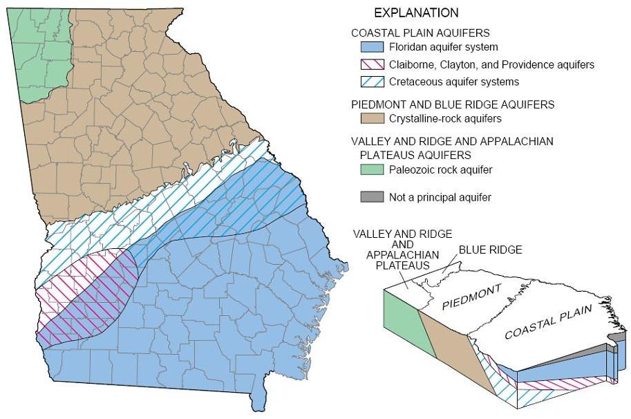
Georgia EPD monitors water quality and water levels in eight aquifers and periodically conducts special studies on groundwater quality such as arsenic, radionuclides, and pesticides. The Georgia Ground-Water Monitoring Network is designed to evaluate the ambient groundwater quality present in Georgia. Groundwater monitoring data, as well as geological maps and information, are published in the Georgia Geologic Survey Publications.
Georgia EPD and USGS have partnered on special studies, such as Georgia Coastal Sound Science Initiative, Coastal Georgia/Upper Floridan/Saltwater Intrusion Modeling, and Southwest Georgia/Agricultural pumping/stream-aquifer interactions.